
“The Felix” was loaded and ready for a fun boondocking adventure through forest and desert, ghost towns and lava flows, rainbow colored ridges and badlands.
Central New Mexico is a splendid place to explore and discover wildlife, geology and spectacular scenery.
Come on along with us for 4 days of camping fun in the Land of Enchantment.
September 28-30 & October 1, 2022
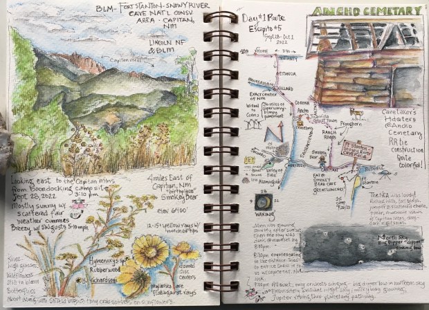
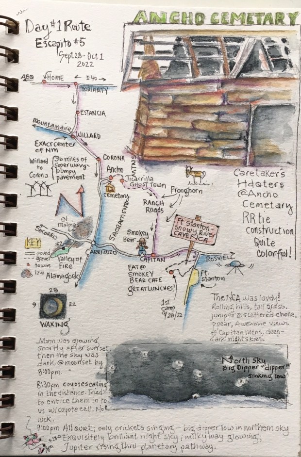
Days 1 & 2, Fort Stanton and Snowy River Cave Recreation Area: Only 155 zig-zag miles southeast of home, we took our time and enjoyed the country of New Mexico’s eastern plains and island mountains. South of Corona, we decided to detour to see what the Jicarilla and Sacramento Mountains had to offer.
As we bounced our way along gravel roads maintained by the Lincoln National Forest we passed through the ghost town of Ancho, pausing for a brief visit. Ancho was originally settled by ranchers and farmers in 1900. When gypsum deposits were discovered in 1902, a plaster mill was built. In 1905 a brick kiln was constructed to make use of the high grade clay found in the surrounding hills. The railroad pushed through to Ancho in 1905. When the devastating 1907 San Francisco earthquake struck, Ancho shipped them plaster and brick to aid in rebuilding.
A bit further along and deeper into the mountains we came upon the ghost town of Jicarilla. Prospectors mined for gold from the 1850s until the early 1930s when the town was occupied by more than 200 residents. Many old buildings still exist, but Jicarilla was abandoned in 1942.
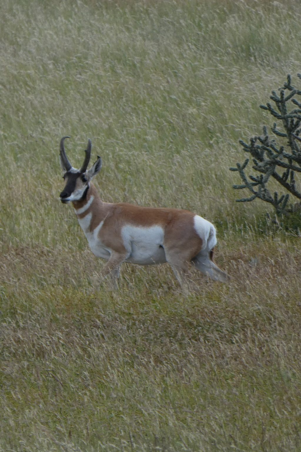
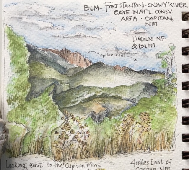
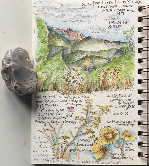
Coming out of the mountains, back to the eastern plains we passed widely spaced cattle ranches, and areas of grazing pronghorn as we made our way to town of Capitan (Smokey Bear country) and finally Fort Stanton and the Snowy River Cave Recreation Area (managed by the Bureau of Land Management or BLM). Beautiful rolling, grass covered hills with some perfect spots for boondocking.
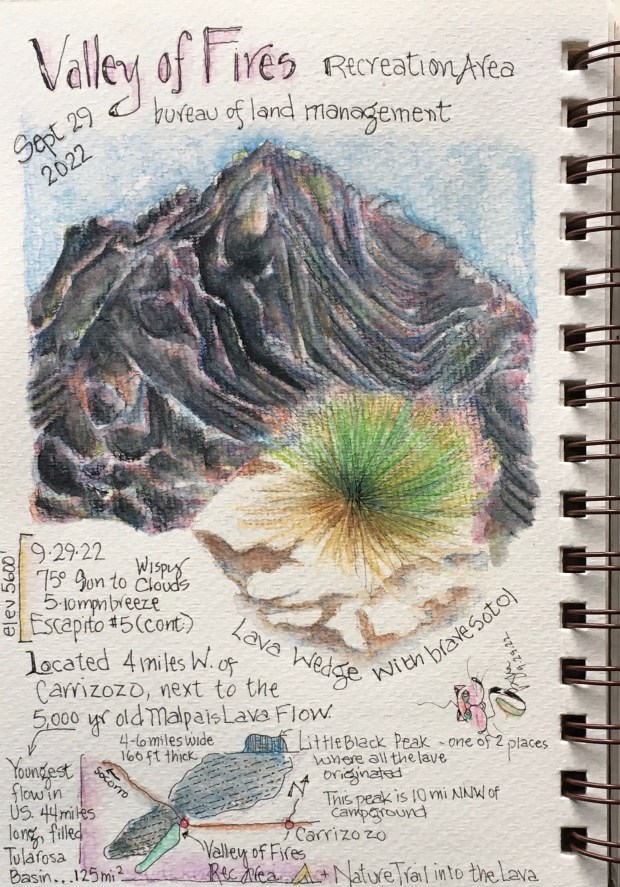
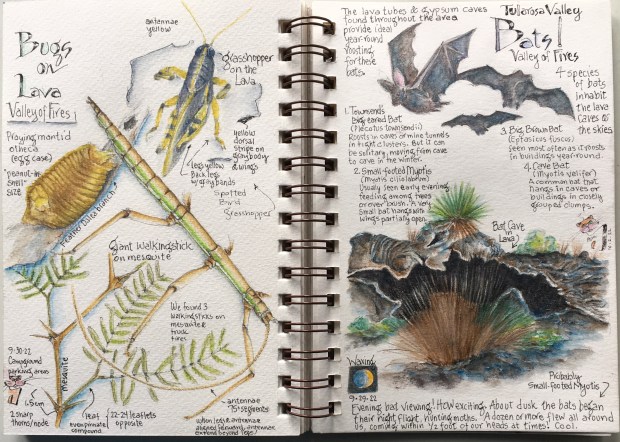
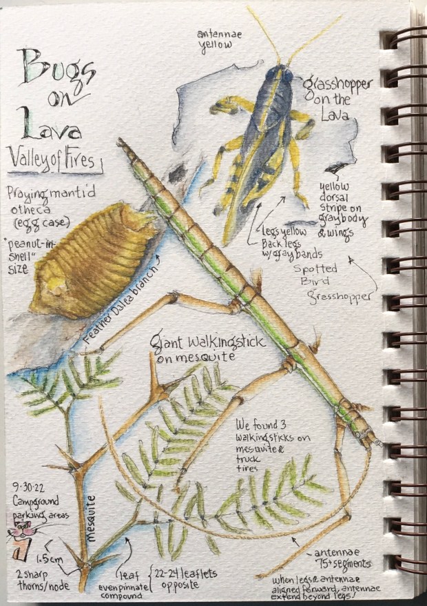
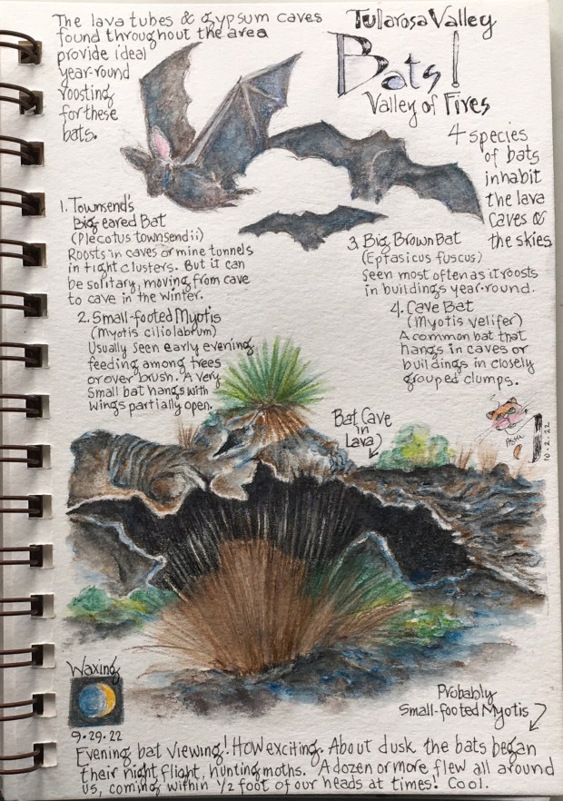
Days 2 & 3, Tularosa Basin and Valley of Fires: Our next destination was to the west. Leaving the Lincoln NF we had a splendid view of the Tularosa Basin and the large 5000 year old lava flow; the Malpais. More than 40 miles of the basin was covered in black ropey lava, that looked ominous and desolate. But the closer we got, we found many plants had gained foothold in the nooks and crannies of the twisted black rocks. Time for us to set down temporary roots in the Valley Of Fires Recreation Area, located within the lava field (another BLM-managed site). We chose a lovely campsite, and spent the day hiking the mile long nature trail, several times, and explored areas off-trail investigating the many plants that call this harsh environment home. The lava deposited many years ago was pushed through tubes and tunnels, and we knew these dark caverns would make ideal bat caves. So at dusk, we hiked the nature trail again to watch hungry bats fly about as they hunted moths and other insects. Great fun!


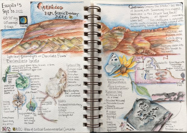
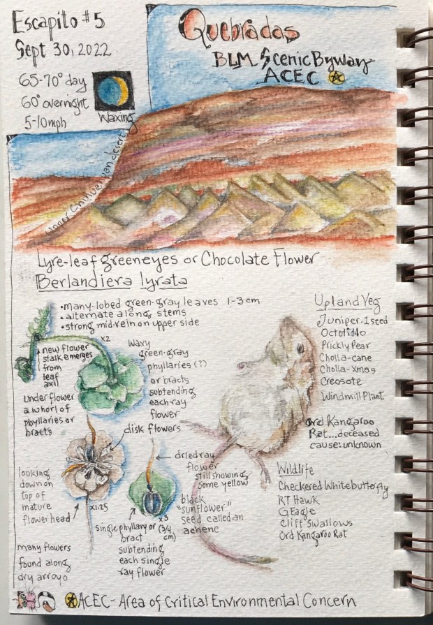
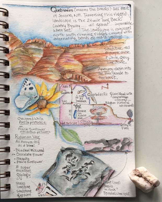
Days 3 & 4, Quebradas Back Country Scenic Byway: After a relaxing morning hiking more lava trails at Valley of Fires, we once again headed a bit northwest, holding our breath as we passed the infamous Trinity Site, to enter one of our favorite areas, the Quebradas (another BLM-managed area).
The Quebradas, which means Breaks, is a 25 mile long area of colorful hills and ridges, badlands, dry arroyos (river beds), and scenic vistas along winding gravel roads in northern Chihuahuan desert habitat. We set up “The Felix” on a breezy rise with a 180-degree view, surrounded by drop offs into several arroyos. Anxious to explore, we hiked for several hours into one of these deep arroyos to learn about the plants, animals and geology of the area.
After a gorgeous night under a sky full of stars, we packed up and resumed our trip north, slowly and carefully bouncing along another 18 miles of gravel roads and deep arroyos for the next 2 hours, until we emerged from the Quebradas into the Rio Grande Valley. Homeward bound after a fun little Escapito.

Thanks for coming along!

Gorgeous photos to view 🌷🙏👍🏻♥️🌷
LikeLike
Thank you very much!
LikeLiked by 1 person
👏🌷💕💝
LikeLiked by 1 person
What a fantastic adventure — bouncing your way to remote places! I’m interested in the butterflies you saw! And the ghost town must have been so interesting. I remember traveling through the widely spaced cattle ranches over on 285 down to Carlsbad, what a lot of wide open country! I would have loved to have seen Pronghorn! It looks like such a gorgeous exploration of geology, plants & animals — thanks for sharing your trip and your beautiful journal pages!
LikeLiked by 1 person
Thanks for coming along, Karen! Always love hearing from you. Especially since you are familiar with New Mexico’s “wide open.” I love being out as it gives me uninterrupted opportunity to sketch in the open, and I put my new travel journal sling satchel I commissioned from a quilter friend through the paces.
Yes, there were still butterflies … some American beauties, the checkered white, a few sulphers and what looked like a Sister floating by. I think we caught the last of the wildflowers for the season as we quickly jumped into fall, currently slogging through a week of drenching rains. But we got off the gravel roads before the arroyos began flooding! Hope you’ve been having fun a great end of summer and early fall up there!
LikeLike
How fun! I’d love to see your quilted sling satchel! I have one that I adore from an Etsy shop with an embroidered bee and bee hive pattern. Our butterflies are sadly done for this season – such a short time! Funny enough, we could use some of your drenching rains — it’s been a very dry summer and fall, and a local forest fire (1 hr. to the north west) has been causing smoke to drift into our area for 2-3 weeks. I look forward to a bit of rain mainly because the mushrooms will be abundant soon!
LikeLiked by 1 person