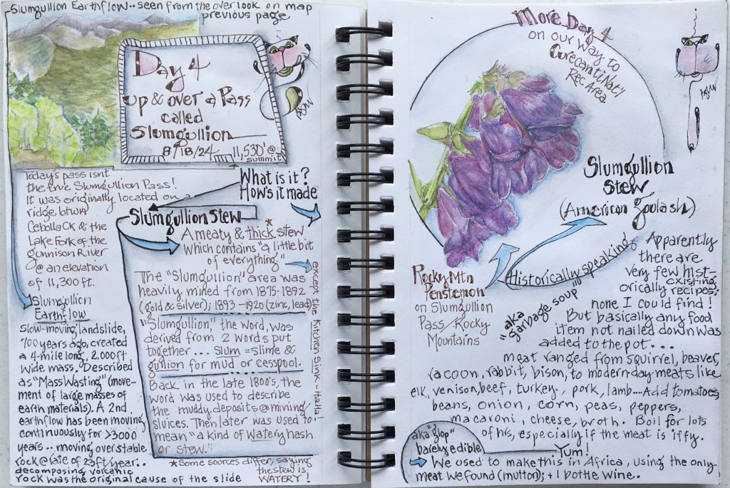
High on the Views: Camping Above the Rio Grande

June 6, 2025

Such an awesome-inspiring place to spend a Spring week in New Mexico!

Three of the five big boys! Rocky Mountain Big Horn Sheep.

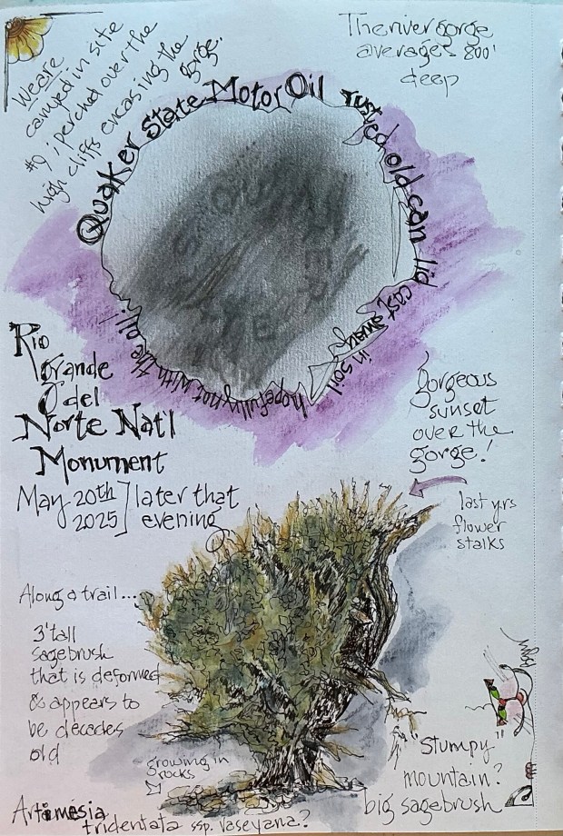
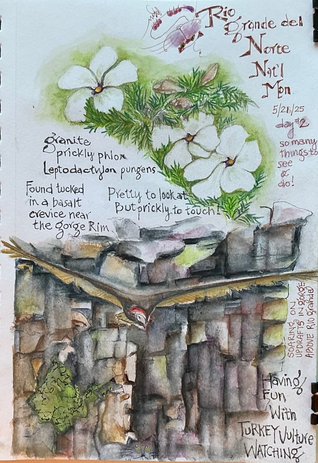
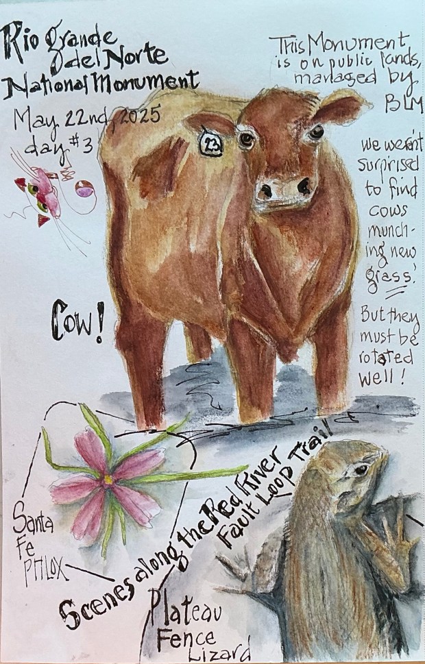
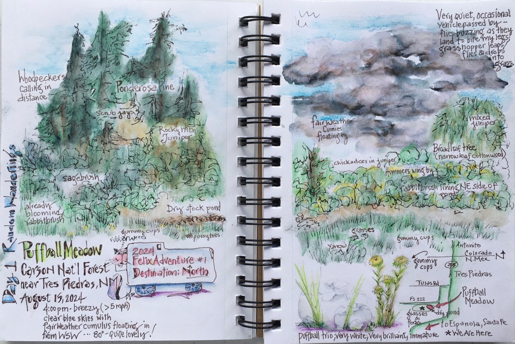
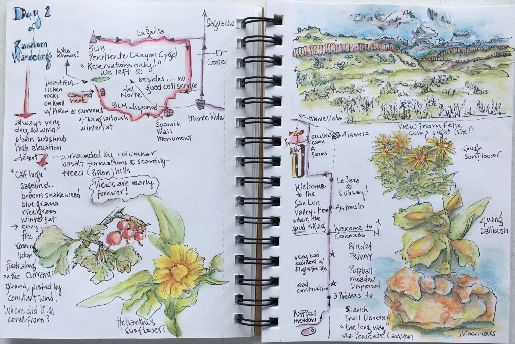
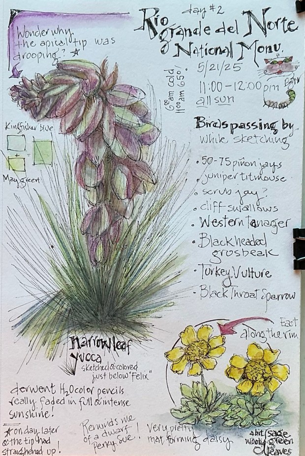
Rio Grande del Norte National Monument ….. 

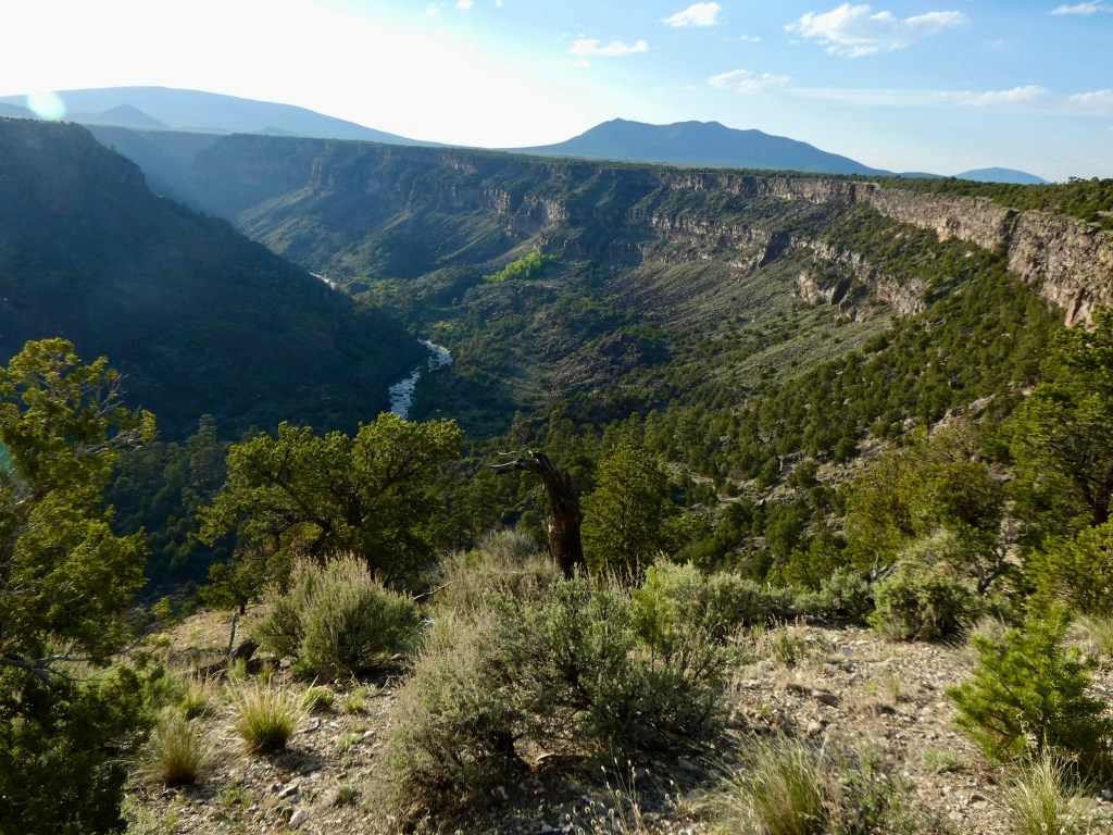
comprises a breathtaking 245,000 acre area of the northern Rio Grande rift valley in north central New Mexico.  Established as a Bureau of Land Management (BLM) national monument in 2013, the rugged wide-open plains average 7,000 feet in elevation before dropping into steep narrow canyons carved into the landscape by rivers that have been flowing for millennia.  

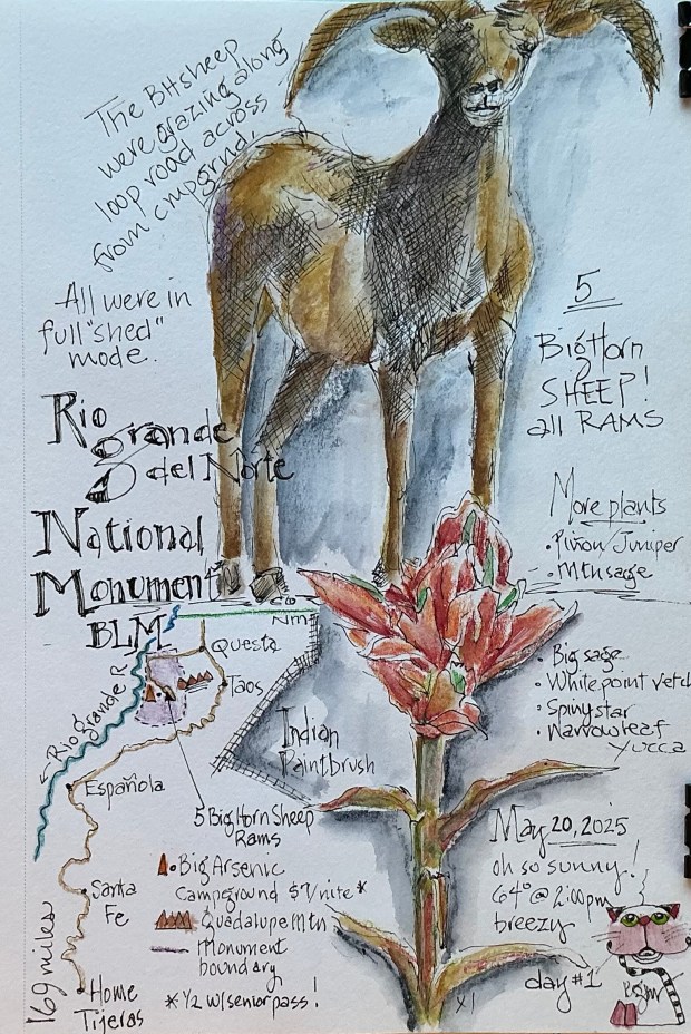
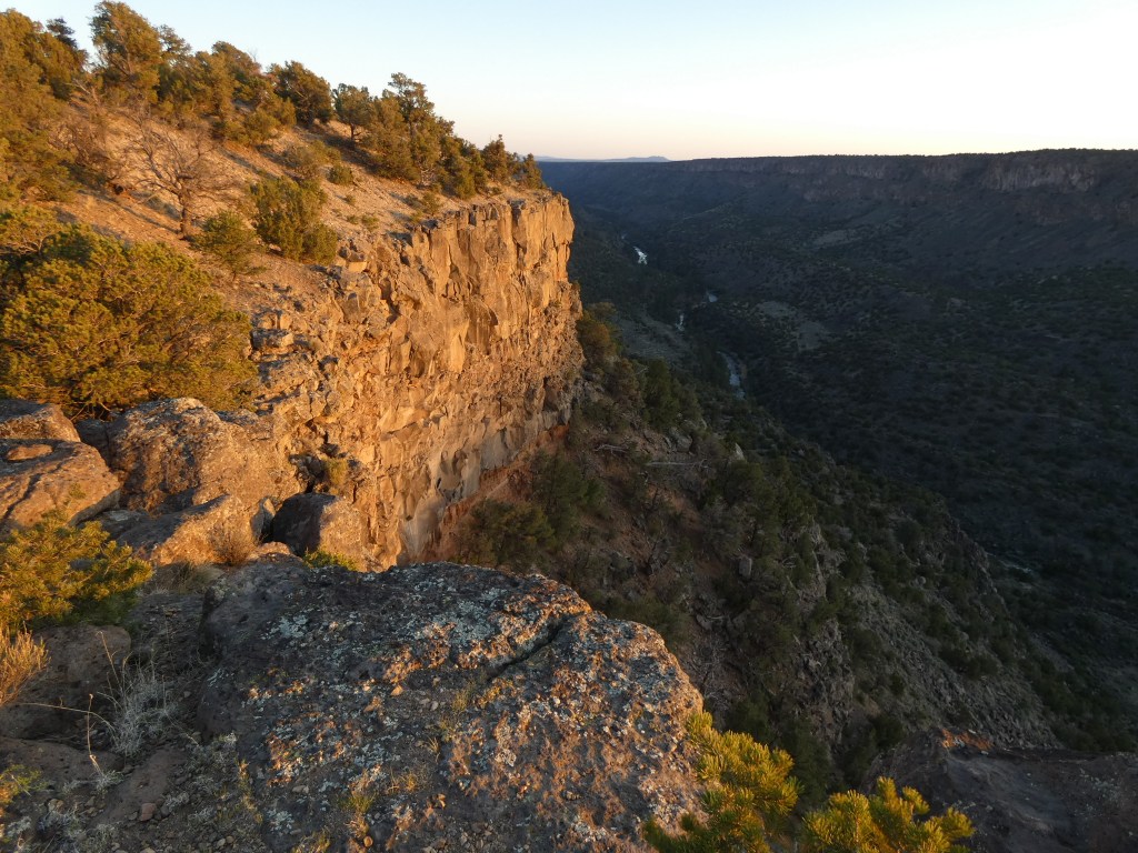
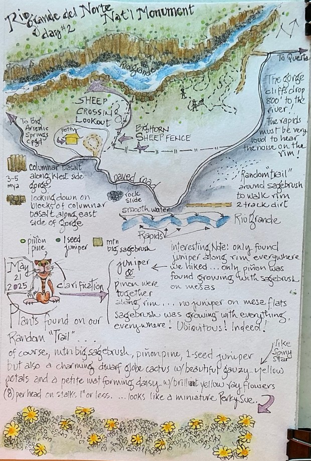
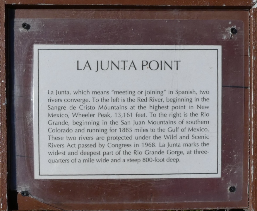
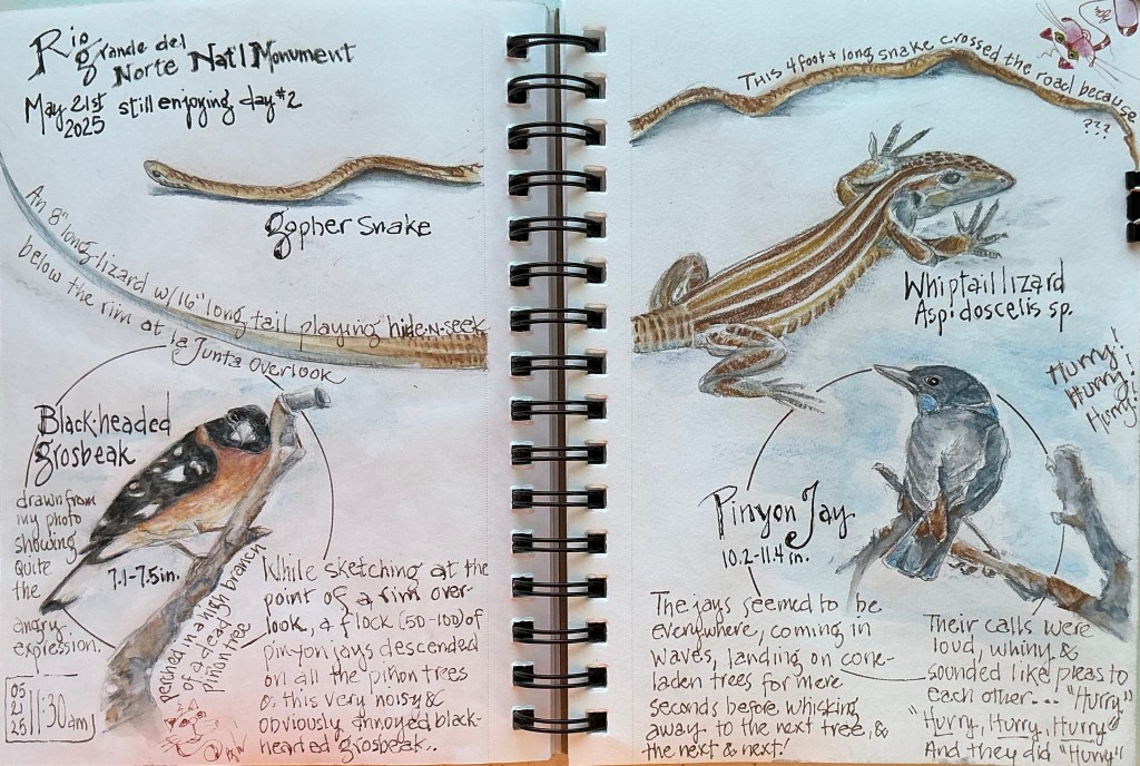
The confluence of two of these rivers, the Rio Grande and the Red River, occurs in the northern Wild Rivers area of the Monument. It’s at this confluence where the gorge is its deepest at 800 feet, and its widest from rim to rim measuring 3/4 mile. It’s an impressive view from the la Junta (“the Meeting”) Overlook. All of the views from anywhere along the rim are impressive.

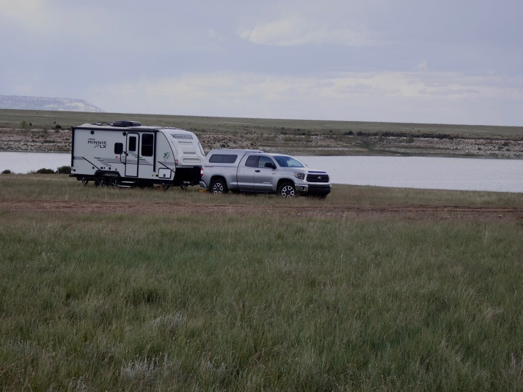
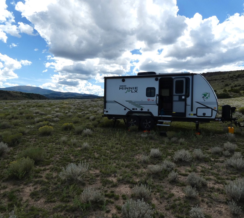
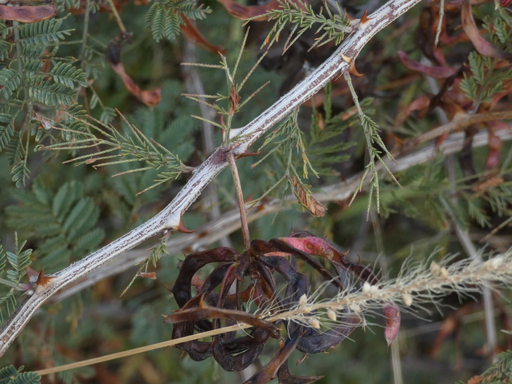
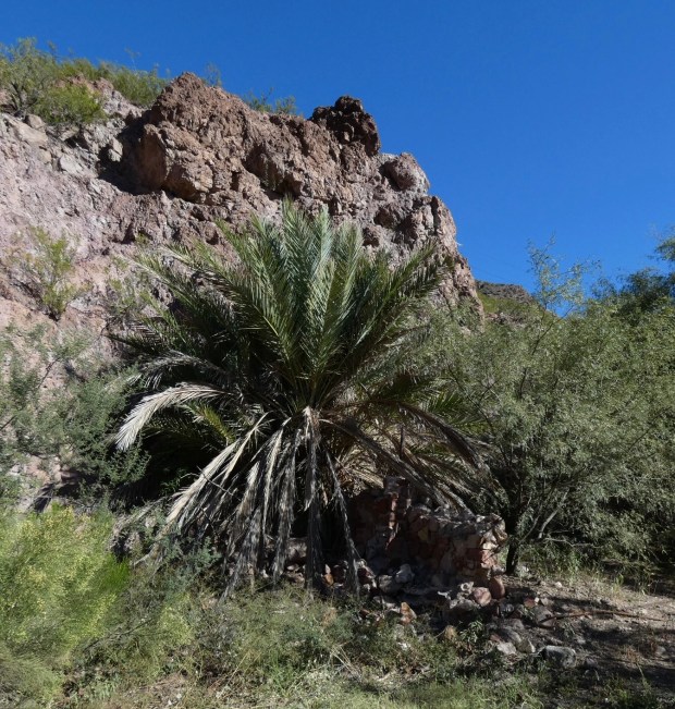
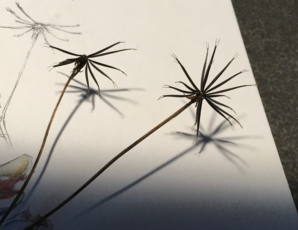
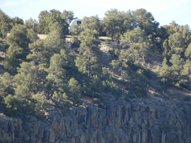
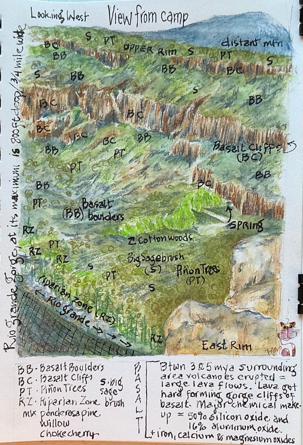
We backed our RV (‘Felix’) into what must’ve been the best designated camping site ever ….. #9 on the southern loop in Big Arsenic Springs Campground. After setting up, we discovered that Felix rested only a few steps west was the rim and the long plunge down to the Rio Grande!  But immediately south of us, the rim formed a small peninsula where nearly every afternoon I could be found sketching the plants growing from the basalt cliffs, or the swifts and turkey vultures soaring along the cliffs and over the river aided by the canyon’s updrafts. This skinny little peninsula quickly became my favorite sit spot; then late one morning it became priceless …….

Can you spot our RV? We were precariously perched above the Rio Grande, right on the rim of the gorge!

I could hear them approaching, like a swarm of bees. In a matter of seconds I was  witnessing a cacophonous chorus of 100’s of pinyon jays. These noisy birds quickly moved in and onward while descending, like they were famished, on this year’s piñon pine cone-laden trees in large erratic groups, all the while screaming, “Hurry, Hurry, Hurry, Hurry!” Where exactly they came from or where they went remains a mystery. All I know was the spectacle must’ve lasted a good 10 minutes or more, as I watched wave after wave of these birds pass by. I still get goosebumps (jaybumps?) recalling those exciting moments.

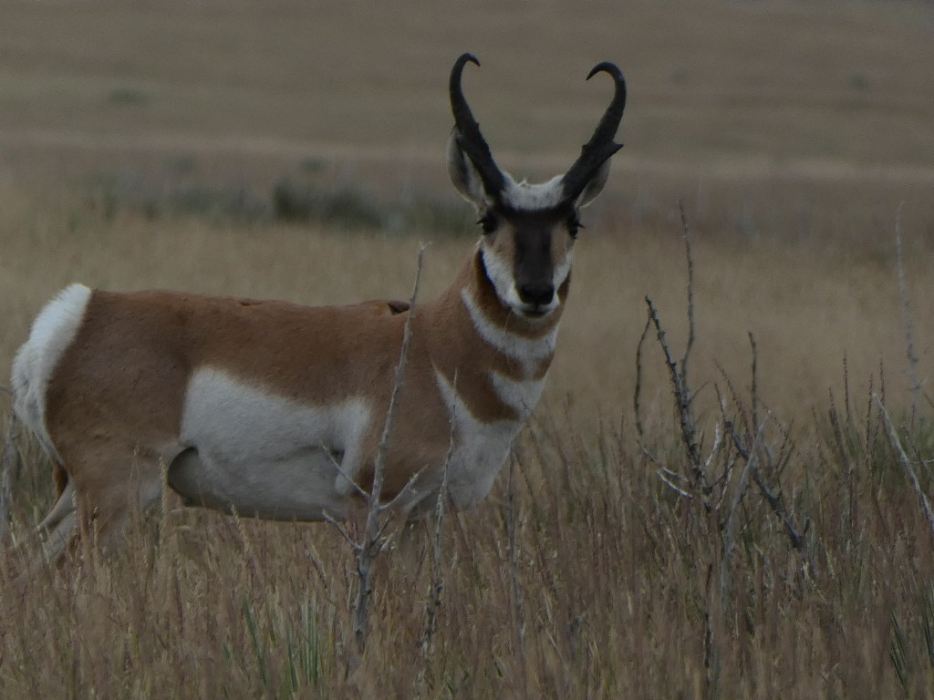
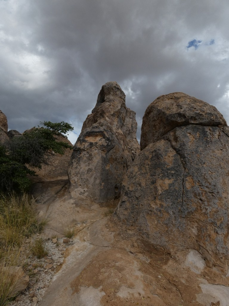
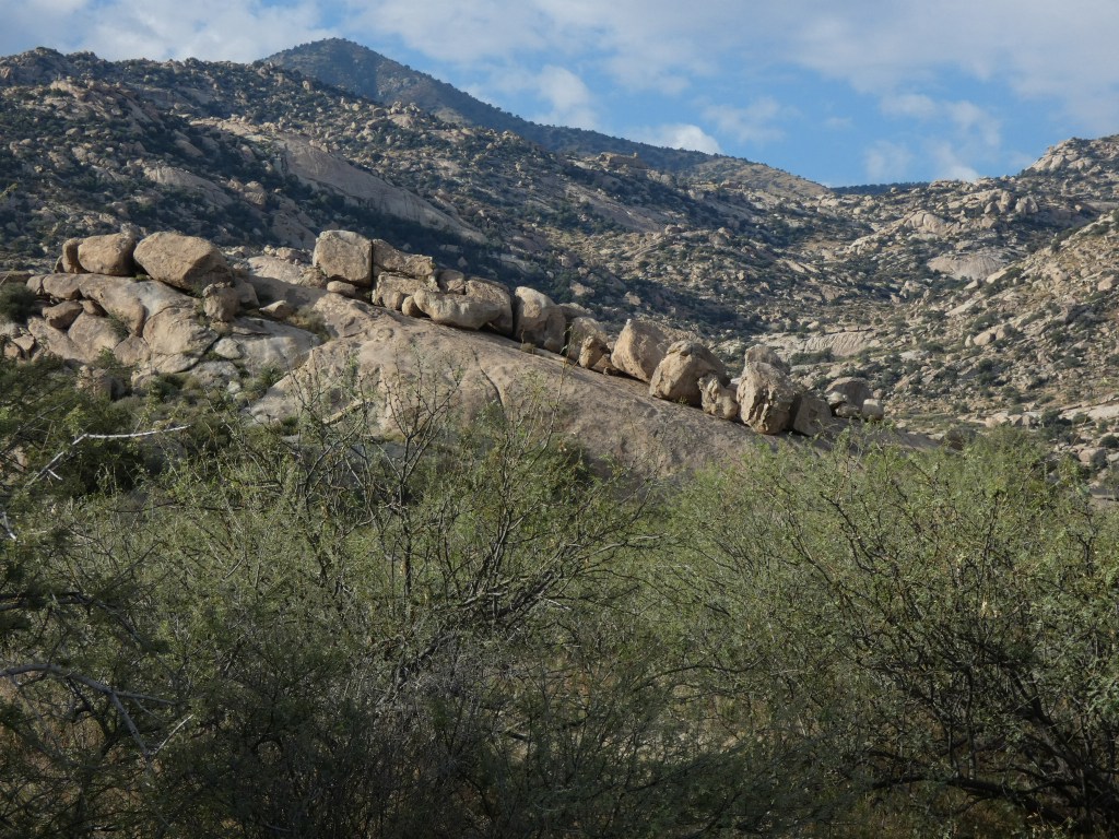
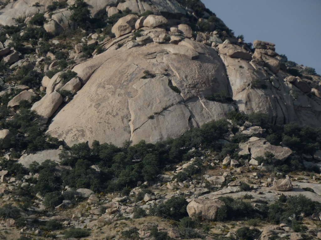
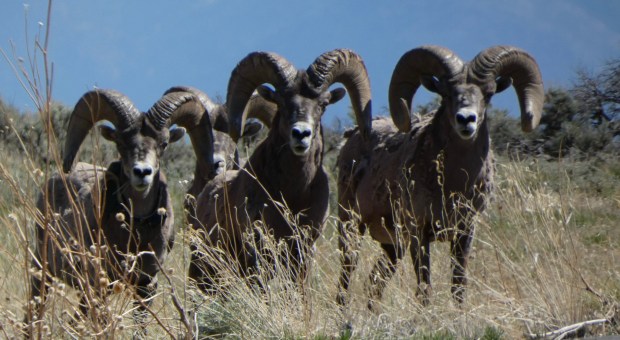
We had planned to spend only one day camping in the Monument, but every morning we decided to stay at least another and then another day. We hiked every rim and interior trail (sometimes more than once), spent hours at all of the Overlooks getting ‘High on the Views,” were thrilled with our chance encounters of five (5) Rocky Mountain Big Horn Sheep rams (twice in one day), and marveled at how the forces of nature* collaborated to carve the narrow and steep 800 foot deep gorge within the Monument.

But alas, it became time to pack up our home away from home. Even tho a string of completely clear days allowed sun to shine on our solar panels from sunup to sundown, keeping Felix’s battery purring happily our entire stay, it did nothing to recharge our potable water tank. So the morning we found the water indicator light teetering on ‘Empty,’ was the day we headed for home (after enjoying a farewell hike, of course) with my nature journal full of sketches and memories for a lifetime!

Do you have an especially special place where you can spend time in nature? Please share your discovery and what makes it so awesome!

As always, thanks for stopping by!

*Geology 101

From the overlooks throughout the Monument, we could see stacks and stacks of basalt and ash lining the narrow canyon walls of the Rio Grande Gorge. It’s hard to imagine the volume of material deposited during two very active periods of volcanic activity that occurred 5 and 3 million years ago. Soon after these events, water moving through the major drainage in the area (today’s Red River) began eroding pathways into these deposits as it flowed downstream into the 10-16 million year old rift valley. Geologists refer to the ancient Red River drainage as the ‘original Rio Grande’ because the still-closed San Luis Basin to the north (in south central Colorado) would not overflow for a few million years. Then 400,000 years ago, coinciding with a change in climate resulting in an overabundance of snow and rain, the San Luis Basin filled and spilled. As water does so well, this new and powerful river, today’s Rio Grande, moved ‘downhill’ towards the ‘original Rio Grande’, cutting through everything in its path (including the ancient volcanic deposits). When it converged with the ‘original Rio Grande,’ the erosive force of both rivers became enough to eventually carve out an 800-foot deep gorge in the Rift.  

Intentional Wanderings; The Grasslands of NE New Mexico

September 15-17, 2024

Sometimes short adventures become the most memorable.  

After pouring over our NM map, looking for new places to camp, based on a recommendation from good friends we decided to visit Charette Lakes.  Located within the grasslands of NE New Mexico, this would be our kind of country. About time to check out the Shortgrass Prairie.  

Planning to be gone 4-5 days, and as long as we were headed to Charette, why not also visit Clayton Lake State Park and Kiowa National Grasslands! The weather certainly looked good for a week, allowing easy access on backcountry 2-track dirt roads.

Felix at home just west of Lower Charette Lake

Charette Lakes

Arriving at Charette Lakes mid-day allowed plenty of time to set up camp with a view of the Lower (larger) lake, before heading off, on foot, to wander these lush grasslands. It seemed like Spring ….. so many wildflowers in bloom! Late afternoon saw a mass exodus of fisherpeople, and by 5:30 pm we pretty much had the entire area to ourselves! Hiking about some more, we encountered a small group of pronghorn, gazed skyward as hungry migratory ducks and Canada geese flew in to Upper Charette Lake, observed a number of beautiful kestrels, and enjoyed the antics of a coot flotilla on the lower lake. 

The wind blew, the rains poured, but we managed several hikes across the short grass prairie surrounding Charette Lakes

By 6:00 pm we got caught in a downpour! Wait! This wasn’t supposed to happen! But the rain and gusty winds persisted until morning, as heavy gray clouds continued to roll by.

We found most of the migratory birds on and feeding at Upper Charette Lake. Mostly marshy and shallow, this small lake had more food for hungry birds than the larger and deeper Lower Charette a lake.

After rechecking the weather forecast, it seemed like this storm was headed north, well out of the area we planned to visit next ….. Clayton Lake State Park, in the extreme NE corner of NM, bordering TX.  

We shook out our rain gear, toweled off the dog, packed up Felix and headed out, dropping down the basalt escarpment we ascended yesterday, thankful this section of steep decline was paved. 

Clayton Lake State Park

Excited to see more of the grasslands and the famous Dinosaur Trackways, a historic landmark site managed by the State Park, we approached from Raton, NM, very close to the Colorado border. Traveling about 50+/- miles SE (leaving the rain behind), the surrounding shortgrass prairie was dotted with a number of resting volcanoes, including Capulin (managed by the National Park Service). 

Our route from Charette Lakes to Clayton Lake State Park and Dinosaur Trackways passed through more shortgrass prairie habitat adjoining a cluster of Forest Service-managed grasslands (Kiowa in NM; Rita Blanca in TX; Cimarron in KS; Comanche in CO), remnants of the vast “sea” of grasslands that used to be.

Arriving at Clayton Lake SP about noon, we quickly parked Felix, then walked the 1/4 mile to the Dino Trackways! Very, very cool. It’s hard to imagine that 100 million years ago this area of NM/TX was a beach along the western side of a great inland sea! Paleontologists believe the dinosaur tracks were made by both plant and meat eaters that migrated north and south along this sandy beach. The tracks showed the plant eaters likely moved about in herds as they foraged for food. There were also foot long tube worm tunnels and some pretty interesting mud cracks preserved in today’s hard sandstone. 

At Clayton Lake State Park we learned about the 100 million years old dinosaur tracks uncovered during the construction of the Clayton Lake emergency spillway, found some wind-stunted and deformed plants lining the the earthen dam, discovered a new grasshopper and beetle, and enjoyed watching terns perform aerobatic stunts over the lake.

Dinner time and it began raining (what!), varying from drizzle to deluge, we started to have second thoughts about tomorrow’s access into Mills Canyon on the Kiowa National Grasslands. But the radar showed this area wasn’t getting rain, and we felt it was worth a try (as long as we were so close!).

One of many cows that graze the grasslands on allotments that often span private, State and Federal lands.

Clayton Lake to Mills Canyon (Kiowa NG)

Early morning sunrise was gorgeous, then from who-knows-where, storm clouds rumbled in, and kept coming nearly the entire way to the Kiowa. But nearing our arrival, the clouds cleared out and things looked promising; so much so that we agreed to try our luck. 

Long abandoned and “melting” into the soil, the shortgrass prairie saw its share of homesteaders back in the middle to late 1800s.

The Grasslands boundary was six miles off the pavement, on dirt and gravel ranch roads. Once on the Grasslands 2-track access to the campground our luck nearly ran out. Down down down the road went, saturated with the last several days of pouring rain. But we didn’t really know this, and began the descent. It wasn’t 200 slippery yards later, Roy’s executive decision to reverse course probably saved us being stranded somewhere for days! As he began backing Felix up the sloppy slick road, conditions somehow felt worse. Felix had a mind of his own and began weaving all over the place, half the time getting stuck in the ruts we made during our descent. 

What looks like a lonely landscape is actually lush and thriving grasslands thanks, in part, to an abundance of rain this year. And Wow! Did it ever rain!

Finally after 30 minutes of careful maneuvering, Roy managed to coax the RV back to the Grasslands boundary. Our relief to be back on somewhat solid ground overshadowed our disappointment in not being able to visit this dramatic canyon area. But we were safe even though both the truck and Felix were coated above the axles with 6-8 inches of mucky sticky clay. 

So, with this area and any other likely destinations soaking wet, and only being 3 hours from home, we agreed to end this crazy camping trip, promising ourselves to return another day. Turns out the decision was wise, as we drove through one downpour after another on the way home! (The rain was so hard at times, visibility was zip! But the good news was it rained so hard that most of that mucky sticky clay got washed away.)

The End…..

And that was the ending to a short, yet memorable trip. Of course by the time we got home, the clouds had cleared totally, and we haven’t had a drop of rain since! Go figure! 

A pronghorn wary of our presence, passing with a herd between Upper and Lower Charette Lakes.


As always, thanks for stopping by!

Random Wanderings; Destination North

August 15-20, 2024

Felix parked along the Old Spanish Trail route, south central Colorado

With no defined route or objective, we decided it was high time we hitch up the trailer (Felix) and tote it north just to see what’s going on in south central Colorado this time of year. As we made our way through the San Luis Valley, we found acres of lush greenery topping almost-ready-to-harvest potatoes. Alfalfa was nearing its second cutting. Carrots had already been shipped to market. The wildlife refuges were patiently awaiting the arrival of migratory birds. And the last of the summer tourists were excitedly boarding the Cumbres and Toltec Scenic Railroad in Antonito, for the 64 mile steam engine journey to Chama, NM.

Day 1. Our first stop was in northern New Mexico, just south of Tres Piedras, Carson NF. An unlikely dispersed camping spot that I nicknamed “Puffball Meadow.” A nice level spot adjacent to a dry stock pond. The meadow was full of fist sized puffball fungi, and a coyote paid us a visit during the night.

We enjoy boondocking on our public lands managed by the US Forest Service and Bureau of Land Management.  Having a trailer that’s self-contained, we can easily find lovely off-the-grid areas to set up camp. And thanks to our solar panels (and lots of sunny days) and large water tank, we can stay out for up to 5 days without needing refills. This allows us to explore lesser visited areas, which suits our tastes beautifully!

Day 2. Made it to the San Luis Valley, Colorado. Wandered around until we found a wide open area of dispersed camping in the vicinity of the Old Spanish Trail. Lots of wildflowers blooming, and plenty of hiking opportunities.

But I think one of the best things about random travel is the spare time …… we drive for 3-4 hours, find a place to camp ….. then the rest of the day involves hiking, wildlife watching, nature journaling, collecting drawable items, photography, more sketching, identifying the unknowns, reading, napping, and a bit of ukulele strumming!  Perfection! 

Day 3. We enjoyed the area so much, Roy suggested we stay for another day! And then he found this weathered mule deer jaw bone.
Day 3, continued. Magpies! Can’t understand why these gorgeous birds don’t come south at least as far as Albuquerque and East Mountains.

Although the 6-day trip wasn’t remarkable, it was good to get away. Scattered about this post are my journal pages highlighting Days 1 to 5. 

Day 4. Our travel route as we made our way to a campground to charge our battery and top off our water tank. An inconvenient, unplanned for detour led to future camping possibilities.

On Day 4, we decided to make our way up and over Slumgullion Pass (11,530 ft) on our way towards Gunnison Country. Not having been this way in years, we really enjoyed the crisp mountain air and spectacular views up and over the Pass. The villages of Creede and Lake City have grown swollen with tourist amenities and summer cabins dotting the once open meadows. As we got closer and closer to Lake City, we couldn’t help recall the story of Colorado’s notorious cannibal, Alferd Packer. Wanting to reread the tale as we passed near Cannibal Plateau and Deadman’s Gulch, the crime scenes, here’s what I found:

Brief Background: Alfred Packer (newspaper misspelling as “Alferd” Packer, which stuck) (1842-1909) was a prospector who set out for Colorado gold fields in 1873. By the winter of 1874, he reached the rugged San Juan Mountains with a party of five men where they became lost and stranded during one of the worst winters on record. The men, with only had 3-4 days provisions quickly consumed and no firearms, were forced to cook their rawhide moccasins. Places where “snow had blown away from patches of wild rose bushes,” ….. they “were gathering buds from these bushes, stewing them and eating them.”

When the snow finally crusted over, Packer, the only man to survive the ill-fated trip, walked out of the mountains after 60 days. He told a story about the demise of his fellow prospectors, and how he managed to survive by eating them. His story involving cannibalism became legend, and continues to be passed down to today! (Whether the story is true or not will never be known, but it makes for colorful history.)

Based on historical records and news reports, Alferd Packer was tried several times for murder and cannibalism (even though the act of cannibalism wasn’t considered illegal in the US). Convicted of these heinous crimes, Judge M.B. Gerry supposedly uttered this famous quote while handing down the sentence in Packer’s first trial …… 

“Stand up yah voracious man-eatin’ sonofabitch and receive yir sintince. When yah came to Hinsdale County, there was siven Dimmycrats. But you, yah et five of ’em, goddam yah. I sintince yah t’ be hanged by th’ neck ontil yer dead, dead, dead, as a warnin’ in reducin’ th’ Dimmycratic populayshun of this county. Packer, you Republican cannibal, I would sintince ya ta hell but the statutes forbid it.”

This is the quote I’d grown up hearing many times, over and over and over! It makes for good reporting, but is a ways from the actual sentence and what Judge Gerry sounded like while reading it (nope, he didn’t talk like Yosemite Sam!).   Here’s what the record shows:

“Alfred Packer, the judgment of this court is that you be removed from hence to the jail of Hinsdale County and there confined until the 19th day of May, A.D. 1883, and that on said 19th day of May, 1883, you be taken from thence by the sheriff of Hinsdale County to a place of execution prepared for this purpose, at some point within the corporate limits of the town of Lake City, in the said country of Hinsdale, and between the hours of 10 A.M. and 3 P.M. of said day, you, then and there, by said sheriff, be hung by the neck until you are dead, dead, dead, and may God have mercy upon your soul.”

Alfred Packer tombstone in Littleton Cemetery where he was originally buried in 1909. Today, he now lies back in Hinsdale County, near Lake City.

Alferd Packer never did hang. It’s quite a detailed story following his first trial, including a jail escape, nine years on-the-lam, and recapture. There was a second trial in 1885 where he was charged for only one murder; after serving only 16 years of his 40-year sentence, he was released and died peacefully one year later at the age of 60. He was buried in Littleton, Colorado where his tombstone properly reads Alfred Packer.

Day 4. Supplemental information about that strange name “Slumgullion.” Is it a stew? Is it a drink? Is it the sludge that puddles below an 1870 sluice box?
Day 5, on our way back to Old Spanish Trail (because we liked it so much). Discovered a new-to-me plant; after a bit of checking with iNaturalist, learned it was Black Henbane, but not before handling all parts of this very poisonous noxious weed!

A short comment on the KG Baking Powder tin lid we found near our trailer. It was old and rusted, but very readable. The tin and its contents were probably long gone. Tried to find any information on the KG brand; sure curious about the age of the lid. If you’ve heard of this brand, please let me know.

KG Baking Powder tin lid we found near Old Spanish Trail.

Day 6. Headed for home. Hope you enjoyed my travel journal.

San Juan Mountains …… up and over Slumgullion Pass. The view of the 700 year old earth flow.


As always, thanks for stopping by!

Rocky Mountain High!

August 10-14, 2023

After sitting idle for many months, The Felix was begging for a short adventure! So we loaded up and off we headed …… north into high elevation Colorado, to enjoy some cool temps and breathtaking scenery. 

A quick 822 mile loop in 4-1/2 days met all of our goals plus we enjoyed afternoon thunderstorms and a few rain showers. 

Follow the link below to read about our trip as I narrate my daily journal pages.

Continue reading “Rocky Mountain High!”

“The Felix” 2023: Escapito #1


Come on along with us for 5 days of camping fun in the Land of Enchantment, where we had some weird and close encounters with botanical beauties, a bare-butted gopher, a swarm of bees, and voracious leaf-footed beetles! All this, and more while exploring a National Conservation Area, a Desert National Monument, and a New Mexico State Park, all within the Chihuahuan desert ecosystem.

Continue reading ““The Felix” 2023: Escapito #1”

Escapito #6: Summer Sequel …. A Desert SW Escape       Part 4: Indian Bread Rocks, AZ to City of Rocks, NM

October 22/23, 2022

We usually know where we’re headed in the morning, but how we get there is another story. As we left Indian Bread Rocks we talked about optional routes to reach our destination …. City of Rocks State Park. There were several choices, and since we’re not interstate highway fans (unless absolutely necessary) we opted for the road less traveled; through New Mexico’s “Bootheel” in the extreme southwestern part of the state.  Going this way we might just catch a glimpse of that infamous Border Wall too.

Although this route was the long way to City of Rocks (200 miles versus 110 miles), it was definitely eye-opening. As we traveled lonely roads, dodging no less than 3 huge rattlesnakes sunning themselves on the pavement, the only vehicles we saw were border patrol. It was windy and hot as we approached the Mexican border, and we strained our eyes to see something resembling a Wall off in the distance.  Between Hachita and Columbus, NM, we could make out what looked to be a RR bed in the valley bottom. Binoculars weren’t much use, as this very straight line wasn’t resolving into a Wall, until ….. all at once we saw the RR track climb straight up a pretty substantial hill. That answered the question …. that faux track was indeed the Border Wall, and we had already seen miles and miles of it.

Border Wall

A short distance out of Columbus, driving very close to the border, we found a side road that appeared to lead down to the Wall, so we went to investigate. Coming within about a quarter mile of the Border Wall we saw how very tall it was, and how it was built with metal slats too close for a person to squeeze through, but spaced and angled just so to see Mexico beyond. 

Border Wall

We’re both glad to have seen this Wall for ourselves. Rest assured I’ve no intention of turning my blog posts into political commentary, but I have to say this obscene border wall is absolutely embarrassing and offensive. 

Border Wall

On to Columbus, North to Deming and to City of Rocks State Park.

Our assigned campsite was a pull through and it was a snap to get The Felix all set up. Then it was off for a nice romp through the assortment of boulders that were created from volcanic tuff and eroded over years to form what appears like, from a distance, a city of high rises. There’s a marked trail through the rock formations that lead you to some of the best rocks and views. But it’s more than okay to wander wherever your legs take you … and sometimes it’s like a maze with many dead ends.  The Park also has a nice botanical garden, many “outside the city” trails, and a super visitor center with helpful volunteer staff offering info like lists of plants, birds, insects, reptiles and mammals you might encounter in the park.

Discovering City of Rocks
Roy and Luna rock hopping

Before a big cold front blew in bringing rain and winds, I was able to do some sketching, we spotted lots of new-to-us plants (still in bloom) and a gorgeous rainbow grasshopper. Several birds (cactus wren, curve-billed thrasher and canyon towhee) paid us a call at The Felix.  About to go searching for the covey of scaled quail making quite a racket somewhere in the rocks, we changed that plan ….. a good decision as we would’ve gotten drenched with rain!

Rainbow grasshopper calling City of Rocks home
The approaching storm made for nice photos
Cat-claw Mimosa

This was our third trip to City of Rocks, and not likely to be our last. It’s a fun place to visit for a short time or an extended stay.

Before the storm

We were going to enjoy one more day in SW NM east of Las Cruces before returning home, but the weather forecast for the next many days called for high winds, rain and snow ….. so, not at all disappointed in all the ground we covered we came home a day early, driving all 283 miles in good time thanks to a tail-wind assist.

(Turns out the next day, had we stayed one day longer, would’ve greeted us with rain, freezing rain and snow by the time we got home. I could feel it in my bones!)

All in all it was a great Escapito #6, all 4 stops and the 922 miles in between, and a fun way to close out the 2022 camping season (or is it?!).  Stay tuned!

Thanks for coming along!

Escapito #6: Summer Sequel …. A Desert SW Escape       Part 3: Clifton, AZ to Indian Bread Rocks, AZ

October 21/22, 2022

Another short (96 miles) drive took us from Clifton, through Safford (to find ice cream ….. it’s getting warm!), and then south of the nearly deserted town of Bowie to visit a sprawling garden of giant granite boulders called Indian Bread Rocks.  We seem to find the most amazing collections of boulders and rocks around, and this area didn’t disappoint. Unable to find out the origin of the name “Indian Bread Rocks,” this new-to-us recreation area sits in the foothills on the northeast fringes of Dos Cabezas Mountains Wilderness Area …. both areas managed by Bureau of Land Management (BLM). Public lands “Rock!”

Scene just before entering Indian Bread Rocks Recreation Area …. Previews! Dos Cabezas Mountains in the background

To access Indian Bread Rocks (maybe the name came from the big loaf-shaped boulders?), you must first pass by a few miles of pistachio orchards looking ready to harvest. Wonder where the irrigation water for these big trees comes from way out in this desert? We then made a southwest turn onto a gravel road (Happy Camp Canyon Road) and in 3 miles we arrived at the designated Indian Bread Rocks picnic area, “sandwiched” between extremely large boulders.  No camping here tho … so we continued on up the deteriorating two track road, pushing bawling cows out of our way. These free-range Brahman bulls, cows and calves turned into camp visitors after we set up about 3/4 mile beyond the picnic area.

Entering Indian Bread Rocks Recreation Area ….. a loaf with a face?

With the rocks calling louder than the bellowing livestock, we brought The Felix to rest and took off on foot, walking further up the dusty road to scope out the area for a longer hike after temps cooled down a bit (85 sunny degrees and loving it!). 

Free range Brahaman cattle

The surrounding granite boulders really were very excellent, and seemed to be animated as well. Many looked like bakery goods; loaves of bread, pancakes, popovers and muffins. Some reminded me of dinosaurs like T-Rex and triceratops. There were precariously balanced hoodoo-like boulders, and many with dark hiding places that make perfect roosting places for bats (which we enjoyed at sunset). 

Discovering Indian Bread Rocks

Indian Bread Rocks plants consist of Chihuahuan desert species with impossible-to-navigate and tire penetrating thorned mesquite, and 6 foot tall spiny prickly pear choking the valley floors. But up small riparian areas (mostly dry washes where water may flow during the monsoon season) we found large oak trees, ocotillo, intermittent water dependent mesquite and cat claw mimosa, sotol and many other shrubs, wildflowers, ferns and grasses. We didn’t hear many birds, but they were around, and we found an assortment of insects (grasshoppers, true bugs, beetles and wasps) flying, hopping and snacking on desert plants. 

A mesquite branch sporting those tire penetrating thorns!

One of the most common insect was the Comanche paper wasp; seen flying everywhere, with exaggeratedly long yellow hind legs hanging down as they flew.  I learned this species of wasp is common here, and colonies of 25-30 build paper nests between the rocks and in the dense vegetation. They didn’t seem aggressive but we were careful to keep The Felix well buttoned up while we explored, as we camped in a small opening surrounded by large velvet mesquite.

Comanche paper wasp warming up in the morning sun
Indian Bread Rocks scenery
Roy and Luna … a bit of a rest from hiking
Indian Bread Rocks scenery

I dare say Indian Bread Rocks was the highlight of our Escapito. It’s always fun to explore new areas. But revisiting familiar areas is also lots of fun. Our next stop, City of Rocks State Park, north of Deming, NM is one of our favorite places ……. for rocks! Can’t get enough.

Stay tuned for Part 4 of this Summer Sequel: Indian Bread Rocks, AZ to City of Rocks, NM 

Escapito #6: Summer Sequel …. A Desert SW Escape       Part 2: Luna Lake, AZ to Clifton, AZ

October 20/21, 2022

Even though we had a mere 97 miles to travel today, we knew the road would be long and winding, up and down, as we dropped over the Mogollon Rim at 8000 feet to the Northern Chihuahua desert at 4000 feet.  And yes indeed, it was a slow go, but worth the drive as we passed through the Apache-Sitgraves National Forest.  This dry forest, dominated by old growth ponderosa pine, had recently burned in many places turning visually impenetrable mountains into scenic, long distance views. As we neared the town of Morenci towards the end of our day, the country literally fell apart due to a gigantic open pit copper mine. We passed by the remains of leveled mountains reconstructed with overburden, impossibly deep terraced pits, and parades of the largest dump trucks ever, carrying freshly blasted raw materials to be processed into copper plates. Morenci is Freeport’s flagship copper mine (Freeport is part of a gigantic international mining conglomerate) and at 62,000 acres in size, there’s every indication of continued expansion. Wow.     

Rugged country north of Clifton

It took about 45 minutes to wind through the countless open pits before we actually reached the town Morenci with Clifton just 10 minutes beyond.  We had arrived; surrounded by desert, with the forest of trees behind us just a memory.

Roy and Luna showing the tire size from one of the dump trucks used at the mine

We stayed at a very nice RV park in North Clifton, being lucky to snare the last available site (all other sites were occupied by miners and their families). The park is advertised as being along the beautiful San Francisco River, which looked like rapidly flowing chocolate milk, but the canyon provided plenty of hiking opportunities …. and we spent the afternoon and following morning exploring, before journeying deeper into the desert.

San Francisco River
Date palm growing beside the San Francisco River
Velvet mesquite growing alongside the San Francisco River

Stay tuned for Part 3: Clifton, AZ to Indian Bread Rocks, Bowie, AZ

Escapito #6: Summer Sequel …. A Desert SW Escape       Part 1: Tijeras, NM to Luna Lake, AZ

October 19/20, 2022

A long first day drive (250 miles) towing The Felix, fully laden, on slow and windy roads. West then south through scenic el Malpais, Quemado (a Catron County stronghold), and into Arizona, all while enjoying beautiful high desert scenery, mountain islands like the Sawtooths (Escapito #3), and open grasslands dotted with pronghorn.  First stop, Springerville for fuel and sticker shock! With only 2 places to buy gas, the Circle K coming into town and the Circle K leaving town, we settled on Circle K.  Hahaha! Fueled up we were back on the road heading south to the pretty little village of Alpine, AZ 8,000 feet high in the Apache-Sitgraves NF. From there it was a short 5 mile hop back east where we found Luna Lake and our forest campground for the night. The Forest Service closed all but one loop, shut off the water for the season, and didn’t charge for camping! Other than 2 other trailers, we pretty much had the place to ourselves and picked a site with a view of the lake. 

Beware the Wicked Seed

Anecdote …… Pins and Needles or The Case of the Wicked Seed: after a long drive we were ready for a hike. But choosing a cross-country trek through tall vegetation was a mistake. Nearly all the wildflowers and grasses had dried and gone to seed, and being fully loaded with ripe seeds, our pant legs, socks and shoestrings provided them an ideal way to disperse. One seed in particular was especially wicked! About 1.5” long and skinny, this hard bugger was tipped with 2 hooks on fork-like tines. Any whisper of contact with these seeds resulted in them leaping out from the seed head and hooking on for a ride.  I’m not sure how their grabbers release their grip and drop to the ground, because when we returned to The Felix, we must’ve been carrying 100s of them embedded in our pants with the bottom ends of the hard sharp-pointy seeds lined up like soldiers ready to attack at the slightest threat of extraction. Ouch! After a consult with iNaturalist, submitting only seed photo, the database turned up one possibility ….. Spanish Needles! A brilliantly named member of the sunflower family. I’ll take dandelion fluff any day!

WIP

We enjoyed our stay at Luna Lake …… in the morning we woke to the sound of elk bugling in the distance, owls hooting overhead, and a respectable coating of frost in everything.  A brisk 1 mile hike on Forest Service roads covering all the campground loops (we weren’t about to venture into the grass ….. oh no way!) warmed us enough to pack up camp and head south in search of summer!

Stay tuned for Part 2: Luna Lake to Clifton, AZ

An excellent cluster of Santa Rita Hedgehog cactus (no matter where you are in the desert SW, watch your step!)

Escapito #5: Public Lands Boondocking through central New Mexico

“The Felix” was loaded and ready for a fun boondocking adventure through forest and desert, ghost towns and lava flows, rainbow colored ridges and badlands.
Central New Mexico is a splendid place to explore and discover wildlife, geology and spectacular scenery.

Come on along with us for 4 days of camping fun in the Land of Enchantment.

Continue reading “Escapito #5: Public Lands Boondocking through central New Mexico”