Red Barberry – An Unforgettable Encounter

July 23, 2025

When you think of ‘Barberry,’ does a shrubby knee-high landscaping bush that transforms to flame red in the fall, come to mind? If so, you may have seen hedge rows of the plant known as Japanese barberry ……

Japanese barberry (Berberis thunbergii) is a non-native shrub that was introduced from Japan in 1875 as an ornamental that’s planted for erosion control and as a living fence. But this invasive shrub outcompetes and displaces native plants, alters ecosystems, and is a host species of black-legged ticks that carry Lyme disease. 

When you think of ‘Holly,’ does a plant with boughs of prickly green leathery leaves naturally ‘decorated’ for the holidays with red berries, come to mind? If so, you’re likely familiar with the iconic American holly ……

American holly (Ilex opaca) is a native shrub of eastern and south-central U.S. that grows well in both dry and swampy soils. The plant, which is also cultivated as an ornamental, forms thick a canopy cover for birds and other wildlife, and the female plants produce an abundance of shocking red berries, loved by birds but poisonous to dogs, cats and humans. Regardless of the risk, bountiful quantities of leafy boughs and clusters of red berries are harvested each fall and brought indoors to create holiday wreaths and other seasonal decorations. 

Red Barberry berries beginning to ripen

Now imagine you’re hiking in a pinyon-juniper forest of the American Southwest. You decide to bushwhack to a connecting trail and all of a sudden find yourself hopelessly stuck in a 10 foot high shrub covered in juicy red berries and very prickly holly-like leaves. This large (somewhat familiar) shrub is a surprisingly effective barricade; a formidable fence. You’ve become entangled in thousands of armed leaves preventing your forward or backwards movement without getting seriously poked and stabbed!

Is this the desert variety of American holly? Maybe it’s the giant living fence of a Japanese barberry gone rogue?

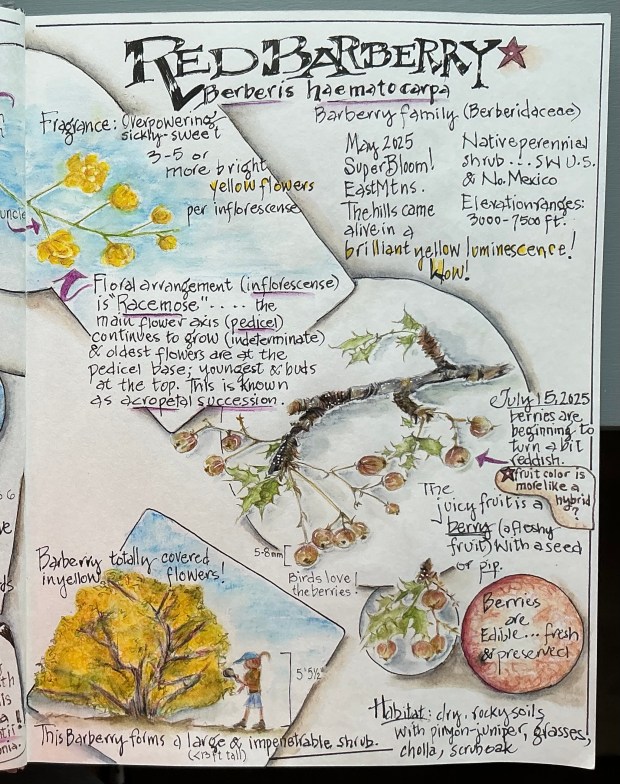
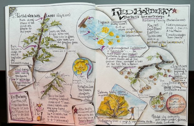
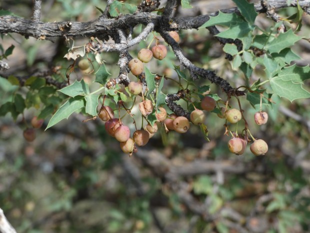
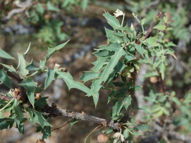
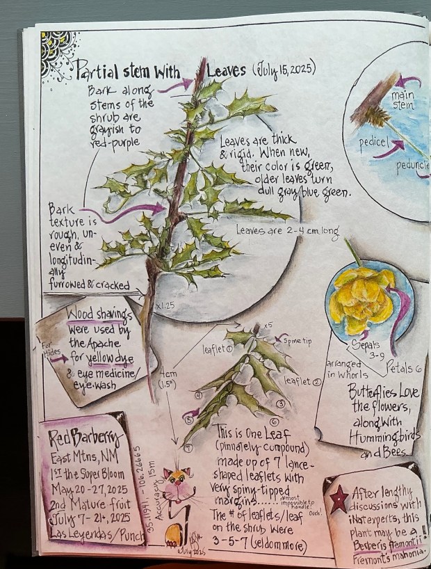
Nope! It’s neither. You’ve stumbled upon (into) a hardy specimen of the desert Southwest native Red Barberry (Berberis haematocarpa). But no wonder you were confused. This shrub, which can grow to 13 feet tall and nearly as wide, has an abundance of holly-shaped leaflets armed by a sharp spine on each lobe tip. And if birds haven’t devoured all of the red berries, you may find an ample supply of a refreshing (albeit tart) snack while you carefully and oh-so-slowly free yourself from the shrub’s embrace.  

Red Barberry leaves – each lobe tip is armed with a needle-like spine

By now you’ve created lasting memories of Red Barberry, and have promised to always be alert for surprise encounters when visiting the desert island Southwest.  

The hiking scenario above conjured up one of my hard-learned lessons from 8 years ago. Having just moved to New Mexico, Roy & I began avidly hiking local trails. Wishing to master the native flora as quickly as possible, one day I discovered clusters of red berries hanging inside the leafy canopy of a 5 foot shrub. What could they be?! Only having eyes for those juicy berries and an irresistible urge to gather a bunch for closer inspection, I plunged my open hand through several layers of small leaflets and successfully clutched a cluster. It was then I realized those spiny leaflets had poked, scratched and even penetrated my bare skin, as evidenced by tiny trickles of blood dripping from my hand and arm! Now that I had captured those pretty berries, it was obvious they had to be released to permit me the delicate maneuvers required to free my arm and minimize further injury. It was that day that I learned all about Red Barberry; lessons that will likely stick with me always!

Red Barberry berries amid armored leaves

Since that close encounter 8 years ago, it’s no surprise I’ve never been a big Red Barberry fan, until ……             

Spring Super Bloom

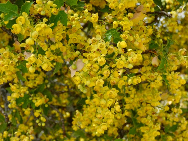
…… this past May a 13 foot tall plant in front of our home burst out in the most spectacular display of sunshine yellow flowers, literally covering the entire shrub front to back; top to bottom! The fragrance was overwhelming for the entire 2+ weeks the flowers were in bloom.  And not only our Barberry was in full bloom, but about a dozen more barberries in our neighborhood and surrounding area were also covered in vibrant yellow. It was an amazing sight, causing me to figuratively re-embrace the native Red Barberry!  

For more tidbits about Red Barberry, browse the text and illustrations displayed on my journal pages.                            Hope you enjoyed this post. 

As always, thanks for stopping by!

P.S. In case you’d like to know about the etymology of the name Berberis haematocarpa……   ‘Berberis’ is a Latinized form of the Arabian name ‘barbaris, for barberry.  “Haematocarpa” means ‘blood-red fruit’ referring to the bright red berries produced by this shrub. The word is derived from the Greek words “haima” (blood) and “karpos” (fruit).

High on the Views: Camping Above the Rio Grande

June 6, 2025

Such an awesome-inspiring place to spend a Spring week in New Mexico!

Three of the five big boys! Rocky Mountain Big Horn Sheep.

Rio Grande del Norte National Monument ….. 

comprises a breathtaking 245,000 acre area of the northern Rio Grande rift valley in north central New Mexico.  Established as a Bureau of Land Management (BLM) national monument in 2013, the rugged wide-open plains average 7,000 feet in elevation before dropping into steep narrow canyons carved into the landscape by rivers that have been flowing for millennia.  

The confluence of two of these rivers, the Rio Grande and the Red River, occurs in the northern Wild Rivers area of the Monument. It’s at this confluence where the gorge is its deepest at 800 feet, and its widest from rim to rim measuring 3/4 mile. It’s an impressive view from the la Junta (“the Meeting”) Overlook. All of the views from anywhere along the rim are impressive.

We backed our RV (‘Felix’) into what must’ve been the best designated camping site ever ….. #9 on the southern loop in Big Arsenic Springs Campground. After setting up, we discovered that Felix rested only a few steps west was the rim and the long plunge down to the Rio Grande!  But immediately south of us, the rim formed a small peninsula where nearly every afternoon I could be found sketching the plants growing from the basalt cliffs, or the swifts and turkey vultures soaring along the cliffs and over the river aided by the canyon’s updrafts. This skinny little peninsula quickly became my favorite sit spot; then late one morning it became priceless …….

Can you spot our RV? We were precariously perched above the Rio Grande, right on the rim of the gorge!

I could hear them approaching, like a swarm of bees. In a matter of seconds I was  witnessing a cacophonous chorus of 100’s of pinyon jays. These noisy birds quickly moved in and onward while descending, like they were famished, on this year’s piñon pine cone-laden trees in large erratic groups, all the while screaming, “Hurry, Hurry, Hurry, Hurry!” Where exactly they came from or where they went remains a mystery. All I know was the spectacle must’ve lasted a good 10 minutes or more, as I watched wave after wave of these birds pass by. I still get goosebumps (jaybumps?) recalling those exciting moments.

We had planned to spend only one day camping in the Monument, but every morning we decided to stay at least another and then another day. We hiked every rim and interior trail (sometimes more than once), spent hours at all of the Overlooks getting ‘High on the Views,” were thrilled with our chance encounters of five (5) Rocky Mountain Big Horn Sheep rams (twice in one day), and marveled at how the forces of nature* collaborated to carve the narrow and steep 800 foot deep gorge within the Monument.

But alas, it became time to pack up our home away from home. Even tho a string of completely clear days allowed sun to shine on our solar panels from sunup to sundown, keeping Felix’s battery purring happily our entire stay, it did nothing to recharge our potable water tank. So the morning we found the water indicator light teetering on ‘Empty,’ was the day we headed for home (after enjoying a farewell hike, of course) with my nature journal full of sketches and memories for a lifetime!

Do you have an especially special place where you can spend time in nature? Please share your discovery and what makes it so awesome!

As always, thanks for stopping by!

*Geology 101

From the overlooks throughout the Monument, we could see stacks and stacks of basalt and ash lining the narrow canyon walls of the Rio Grande Gorge. It’s hard to imagine the volume of material deposited during two very active periods of volcanic activity that occurred 5 and 3 million years ago. Soon after these events, water moving through the major drainage in the area (today’s Red River) began eroding pathways into these deposits as it flowed downstream into the 10-16 million year old rift valley. Geologists refer to the ancient Red River drainage as the ‘original Rio Grande’ because the still-closed San Luis Basin to the north (in south central Colorado) would not overflow for a few million years. Then 400,000 years ago, coinciding with a change in climate resulting in an overabundance of snow and rain, the San Luis Basin filled and spilled. As water does so well, this new and powerful river, today’s Rio Grande, moved ‘downhill’ towards the ‘original Rio Grande’, cutting through everything in its path (including the ancient volcanic deposits). When it converged with the ‘original Rio Grande,’ the erosive force of both rivers became enough to eventually carve out an 800-foot deep gorge in the Rift.  

Intentional Wanderings; The Grasslands of NE New Mexico

September 15-17, 2024

Sometimes short adventures become the most memorable.  

After pouring over our NM map, looking for new places to camp, based on a recommendation from good friends we decided to visit Charette Lakes.  Located within the grasslands of NE New Mexico, this would be our kind of country. About time to check out the Shortgrass Prairie.  

Planning to be gone 4-5 days, and as long as we were headed to Charette, why not also visit Clayton Lake State Park and Kiowa National Grasslands! The weather certainly looked good for a week, allowing easy access on backcountry 2-track dirt roads.

Felix at home just west of Lower Charette Lake

Charette Lakes

Arriving at Charette Lakes mid-day allowed plenty of time to set up camp with a view of the Lower (larger) lake, before heading off, on foot, to wander these lush grasslands. It seemed like Spring ….. so many wildflowers in bloom! Late afternoon saw a mass exodus of fisherpeople, and by 5:30 pm we pretty much had the entire area to ourselves! Hiking about some more, we encountered a small group of pronghorn, gazed skyward as hungry migratory ducks and Canada geese flew in to Upper Charette Lake, observed a number of beautiful kestrels, and enjoyed the antics of a coot flotilla on the lower lake. 

The wind blew, the rains poured, but we managed several hikes across the short grass prairie surrounding Charette Lakes

By 6:00 pm we got caught in a downpour! Wait! This wasn’t supposed to happen! But the rain and gusty winds persisted until morning, as heavy gray clouds continued to roll by.

We found most of the migratory birds on and feeding at Upper Charette Lake. Mostly marshy and shallow, this small lake had more food for hungry birds than the larger and deeper Lower Charette a lake.

After rechecking the weather forecast, it seemed like this storm was headed north, well out of the area we planned to visit next ….. Clayton Lake State Park, in the extreme NE corner of NM, bordering TX.  

We shook out our rain gear, toweled off the dog, packed up Felix and headed out, dropping down the basalt escarpment we ascended yesterday, thankful this section of steep decline was paved. 

Clayton Lake State Park

Excited to see more of the grasslands and the famous Dinosaur Trackways, a historic landmark site managed by the State Park, we approached from Raton, NM, very close to the Colorado border. Traveling about 50+/- miles SE (leaving the rain behind), the surrounding shortgrass prairie was dotted with a number of resting volcanoes, including Capulin (managed by the National Park Service). 

Our route from Charette Lakes to Clayton Lake State Park and Dinosaur Trackways passed through more shortgrass prairie habitat adjoining a cluster of Forest Service-managed grasslands (Kiowa in NM; Rita Blanca in TX; Cimarron in KS; Comanche in CO), remnants of the vast “sea” of grasslands that used to be.

Arriving at Clayton Lake SP about noon, we quickly parked Felix, then walked the 1/4 mile to the Dino Trackways! Very, very cool. It’s hard to imagine that 100 million years ago this area of NM/TX was a beach along the western side of a great inland sea! Paleontologists believe the dinosaur tracks were made by both plant and meat eaters that migrated north and south along this sandy beach. The tracks showed the plant eaters likely moved about in herds as they foraged for food. There were also foot long tube worm tunnels and some pretty interesting mud cracks preserved in today’s hard sandstone. 

At Clayton Lake State Park we learned about the 100 million years old dinosaur tracks uncovered during the construction of the Clayton Lake emergency spillway, found some wind-stunted and deformed plants lining the the earthen dam, discovered a new grasshopper and beetle, and enjoyed watching terns perform aerobatic stunts over the lake.

Dinner time and it began raining (what!), varying from drizzle to deluge, we started to have second thoughts about tomorrow’s access into Mills Canyon on the Kiowa National Grasslands. But the radar showed this area wasn’t getting rain, and we felt it was worth a try (as long as we were so close!).

One of many cows that graze the grasslands on allotments that often span private, State and Federal lands.

Clayton Lake to Mills Canyon (Kiowa NG)

Early morning sunrise was gorgeous, then from who-knows-where, storm clouds rumbled in, and kept coming nearly the entire way to the Kiowa. But nearing our arrival, the clouds cleared out and things looked promising; so much so that we agreed to try our luck. 

Long abandoned and “melting” into the soil, the shortgrass prairie saw its share of homesteaders back in the middle to late 1800s.

The Grasslands boundary was six miles off the pavement, on dirt and gravel ranch roads. Once on the Grasslands 2-track access to the campground our luck nearly ran out. Down down down the road went, saturated with the last several days of pouring rain. But we didn’t really know this, and began the descent. It wasn’t 200 slippery yards later, Roy’s executive decision to reverse course probably saved us being stranded somewhere for days! As he began backing Felix up the sloppy slick road, conditions somehow felt worse. Felix had a mind of his own and began weaving all over the place, half the time getting stuck in the ruts we made during our descent. 

What looks like a lonely landscape is actually lush and thriving grasslands thanks, in part, to an abundance of rain this year. And Wow! Did it ever rain!

Finally after 30 minutes of careful maneuvering, Roy managed to coax the RV back to the Grasslands boundary. Our relief to be back on somewhat solid ground overshadowed our disappointment in not being able to visit this dramatic canyon area. But we were safe even though both the truck and Felix were coated above the axles with 6-8 inches of mucky sticky clay. 

So, with this area and any other likely destinations soaking wet, and only being 3 hours from home, we agreed to end this crazy camping trip, promising ourselves to return another day. Turns out the decision was wise, as we drove through one downpour after another on the way home! (The rain was so hard at times, visibility was zip! But the good news was it rained so hard that most of that mucky sticky clay got washed away.)

The End…..

And that was the ending to a short, yet memorable trip. Of course by the time we got home, the clouds had cleared totally, and we haven’t had a drop of rain since! Go figure! 

A pronghorn wary of our presence, passing with a herd between Upper and Lower Charette Lakes.


As always, thanks for stopping by!

Meet an “Extreme” Creative!

April 8, 2024

After years of on-line and email chats, I was delighted when my friend Robin Atkins decided it was finally time we met in person! Bravo!

Robin and her travel buddy Lunnette, drove over 1,800 miles to Tucson to teach a Spirit Doll class to a local beading group. Then after spending 5+ days exploring Tucson and before driving home to Friday Harbor on San Juan Island, WA, they took a “short” scenic 450 mile detour …… to Tijeras, NM. This out-of-the way drive would bring them to our doorstep, and our first face-to-face meeting! While in Tijeras, we were able to spend an evening and full day getting to know each other and spent time hiking, nature sketching, and sharing each other’s art.

Robin snapped this photo of me sketching out at Golden Open Space. The beautiful wind sculpted juniper trees growing along the precipices of the windy observation areas are absolutely captivating (and tough). Luna thinks they’re tasty!

Meet Robin

Robin, whom I’ve always thought of as an “extreme creative,” is a fascinating, energetic, curious, passionate and bright-eyed adventurer in her early 80s. Her many interests and skills, in addition to creating uniquely designed, hand sewn and beaded Spirit Dolls, include: quilting (many with bead embellishments), thread embroidery, book making, watercolor painting, Zentangle art, nature journaling, making decorative papers, poetry, weaving, collage, crochet, felting and book author. And she shares her skills and techniques by teaching. 

This isn’t an exhaustive list by any means! As someone who seems to thrive on learning and developing new skills, Robin never stops seeking artistic challenges to take on. 

Check out Robin’s beautiful webpage and blog (http://robinatkins.com) where you can find photos and posts highlighting her current and past creative projects. 

A Short-but-Sweet Visit

We had a wonderful time getting to know each other, and what a delight to have also met Robin’s long-time friend and travel buddy, Lunnette. A retired firefighter in her mid 70s, Lunnette is also a nature journaler, calligrapher, quilter, and according to Robin, “she’s a terrific navigator, who always uses her keen sense of direction and map reading skills to keep us on the “right road,” (in both the literal and figurative sense).”

This is my finished graphite drawing of the twisted juniper I spent 5 minutes sketching.

Parting company was hard, but Robin and Lunnette needed to return home. Along their route they visited both Mesa Verde National Park and Arches National Park, soaking in more of the desert southwest sun and culture before taking on the 1,200 mile journey for Friday Harbor.

Memories!